![]()
![]()
![]()
|
|
|
|
The Route planner is accessed from a module on the home screen or a location on the menu bar. Depending on the configuration, you may need to look at the menus to locate it. More simply, to access from the module on the home screen, click Enter Details on the module. This will take you directly to the Route planner page.
Once opened a map is displayed on the right. The panel on the left allows you to select the mode of travel you will be using, two or more locations and options.
Mode of travel
Four buttons are available to select the mode of transport as follows:
|
By car (default) |
|
By public transport |
|
Walking |
|
Bicycling |
Depending on the mode of transport selected, additional options may be available.
Add destination
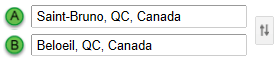
By default, two locations are available. Normally you will type the start location in box A and the end location in box B. However, you can also add more locations along the way if you wish to follow a specific route with the exception of By public transport which is limited to two locations. To do this, click Add destination. You can repeat to add more destinations. Type a location in each box in the order they should be mapped. If you wish, you can reverse the direction of travel by clicking ![]() to the right of the locations, the following illustration shows how this might look:
to the right of the locations, the following illustration shows how this might look:
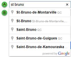
When you start typing a location, a lookup list should appear. To simplify use, select whichever most closely matches your requirements.
Show options
Depending on the mode of travel selected, you can select options. Click Select options to view them for the selected mode of travel. These are described below:
By default, distances are provided in km. Select Miles if you wish to change to this measurement.
There are two check boxes you can select if you wish to apply these filters:
When using public transport you can coordinate with transport timings by using the options to:
Selecting either Depart at or Arrive by enables the calendar and time picker. Click on each in turn to choose a day and a time.
Note: You cannot select a specific time until you have selected a date in the future.
Get directions
Once you have made all your selections and entered the locations, click GET DIRECTIONS.
A list of directions is now presented at the bottom of the panel, normally with Suggested routes at the top. Click one to choose it or accept the default. Scroll down to view the full list of directions.
The plotted locations are marked for you on the map with public transport details if applicable. The final destination has a red marker, all other locations have a green marker. The route itself is marked in blue.
Tip: It is useful to know that, if you selected the wrong mode of transport at the start or you wish to see the alternatives, you can change the mode of transport after the route and options are fully plotted. The map will update to the route that matches the new mode of transport without the need to re-enter the locations.